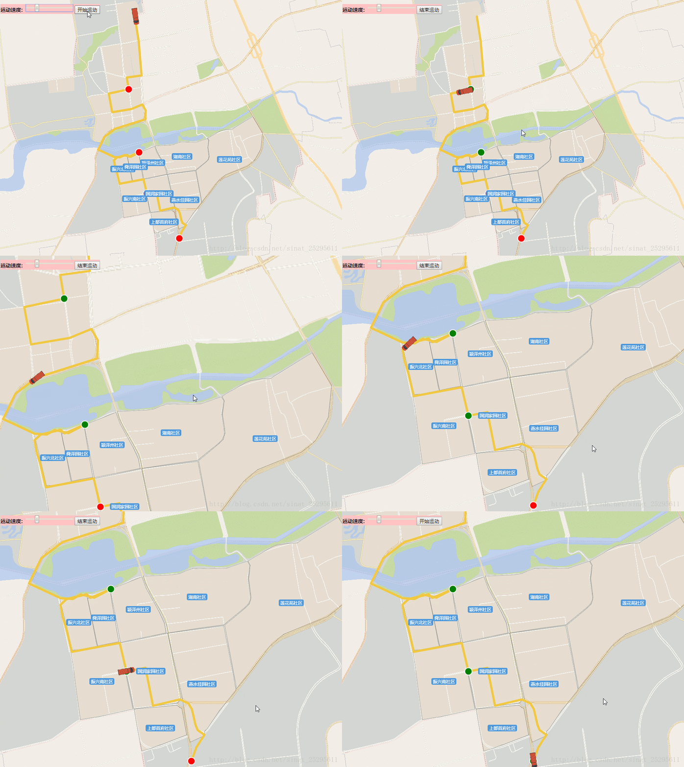
本文实例为大家分享了openlayers 3实现车辆轨迹回放的具体代码,供大家参考,具体内容如下
先上效果:

利用 openlayers 3地图的 postcompose 事件监听地图的重绘
注意:此代码是我在Vue 的methods 里面写的测试方法,并不能直接运行,请在理解的基础上测试。
vm 为vue的this对象 注释已经很丰富了,先做个备份,后期会编辑加入一点详解。
实现代码:
html:
|
1
2
3
4
5
6
7
8
9
10
|
<div id="menu"> <label for="speed" style="font-weight: bold;"> 运动速度: <input id="speed" type="range" min="1" max="20" step="1" value="10" /> </label> <button id="start-animation"> 开始运动 </button> </div><!-- 注:此代码仅为上面速度条和按钮-- |
核心代码:
|
1
2
3
4
5
6
7
8
9
10
11
12
13
14
15
16
17
18
19
20
21
22
23
24
25
26
27
28
29
30
31
32
33
34
35
36
37
38
39
40
41
42
43
44
45
46
47
48
49
50
51
52
53
54
55
56
57
58
59
60
61
62
63
64
65
66
67
68
69
70
71
72
73
74
75
76
77
78
79
80
81
82
83
84
85
86
87
88
89
90
91
92
93
94
95
96
97
98
99
100
101
102
103
104
105
106
107
108
109
110
111
112
113
114
115
116
117
118
119
120
121
122
123
124
125
126
127
128
129
130
131
132
133
134
135
136
137
138
139
140
141
142
143
144
145
146
147
148
149
150
151
152
153
154
155
156
157
158
159
160
161
162
163
164
165
166
167
168
169
170
171
172
173
174
175
176
177
178
179
180
181
182
183
184
185
186
187
188
189
190
191
192
193
194
195
196
197
198
199
200
201
202
203
204
205
206
207
208
209
210
211
212
213
214
215
216
217
218
219
220
221
222
223
224
225
226
227
228
229
230
231
232
233
234
235
236
237
238
239
240
241
242
243
244
245
246
247
248
249
250
251
252
253
254
255
256
257
258
259
260
261
262
263
264
265
266
267
268
|
startMove:function () { var vm=this; var map=vm.map; vm.clearOverlayers("beijing_sq"); //中间站 var stops=[ [12909554.6597,4933234.84552], //14 [12909824.6852,4931594.7854], //43 [12910026.8837,4930523.89946], //63 [12910870.563,4929357.26511] //85 ]; var stopMakers = new Array(); for(var i=0;i<4;i++){ var s = new ol.Feature({ type: 'stop', geometry: new ol.geom.Point(stops[i]) }); stopMakers.push(s); } var Coordinates=vm.path; //将离散点构建成一条折线 var route = new ol.geom.LineString(Coordinates); //获取直线的坐标 var routeCoords = route.getCoordinates(); var routeLength = routeCoords.length; var routeFeature = new ol.Feature({ type: 'route', geometry: route }); var geoMarker = new ol.Feature({ type: 'geoMarker', geometry: new ol.geom.Point(routeCoords[0]) }); var startMarker = new ol.Feature({ type: 'icon', geometry: new ol.geom.Point(routeCoords[0]) }); var endMarker = new ol.Feature({ type: 'icon', geometry: new ol.geom.Point(routeCoords[routeLength - 1]) }); var styles = { 'route': new ol.style.Style({ stroke: new ol.style.Stroke({ width: 6, color: '#F2C841' }), fill:new ol.style.Fill({ color:"#F6E3A3" }) }), /*'icon': new ol.style.Style({ image: new ol.style.Icon({ anchor: [0.5, 1], src: require() }) }),*/ 'geoMarker': new ol.style.Style({ /*image: new ol.style.Circle({ radius: 7, snapToPixel: false, fill: new ol.style.Fill({ color: 'black' }), stroke: new ol.style.Stroke({ color: 'white', width: 2 }) })*/ image: new ol.style.Icon({ src: require('../../assets/map/left_red_car.png'), rotateWithView: false, rotation: -Math.atan2(routeCoords[0][1]-routeCoords[1][1], routeCoords[0][0]-routeCoords[1][0]), scale:0.3, }) }), 'stop':new ol.style.Style({ image:new ol.style.Circle({ radius:10, snapToPixel:false, fill:new ol.style.Fill({ color:'red'}), stroke:new ol.style.Stroke({ color:'white', width:2 }) }) }) }; var animating = false; var speed, now; var speedInput = document.getElementById('speed'); var startButton = document.getElementById('start-animation'); var vectorLayer = new ol.layer.Vector({ id:'carLayer', source: new ol.source.Vector({ features: [routeFeature, geoMarker, startMarker, endMarker,stopMakers[0],stopMakers[1],stopMakers[2],stopMakers[3]] }), style: function (feature) { //如果动画是激活的就隐藏geoMarker if (animating && feature.get('type') === 'geoMarker') { return null; } return styles[feature.get('type')]; } }); //var center = ol.proj.fromLonLat([115.981,40.451]); map.addLayer(vectorLayer); // 要素移动 var moveFeature = function (event) { var vectorContext = event.vectorContext; //HTML5 Canvas context,ol.render.canvas.Immediate的对象 var frameState = event.frameState; //freme 的状态 if (animating) { var elapsedTime = frameState.time - now; //elapsedTime 已过时间 //通过增加速度,来获得lineString坐标 var index = Math.round(speed * elapsedTime / 1000); //已经走了多少个点 //console.log("#########",routeCoords[index]); if (index >= routeLength) { stopAnimation(true); return; } //fixme --------------- if( index < 14){ flashFeature(0); } if( index == 14){ changeStyle(0, 1); } if(index > 14 && index <43){ flashFeature(1); } if(index == 43){ changeStyle(1, 2); } if(index > 43 && index <63){ flashFeature(2); } if(index == 63){ changeStyle(2, 3); } if(index > 63 && index <85){ flashFeature(3); } if(index == 85){ changeStyle(3, 3); } //fixme-------------------- var dx,dy,rotation,carStyle; if(routeCoords[index] && routeCoords[index+1]){ dx=routeCoords[index][0]-routeCoords[index+1][0]; dy=routeCoords[index][1]-routeCoords[index+1][1]; rotation = Math.atan2(dy,dx); //console.log("***********",rotation); carStyle= new ol.style.Style({ image: new ol.style.Icon({ src: require('../../assets/map/left_red_car.png'), rotateWithView: false, rotation: -rotation, scale:0.3, }) }); var currentPoint = new ol.geom.Point(routeCoords[index]); //当前点 var feature = new ol.Feature(currentPoint); //Render a feature into the canvas. // Note that any zIndex on the provided style will be ignored - features are rendered immediately in the order that this method is called. // If you need zIndex support, you should be using an ol.layer.Vector instead vectorContext.drawFeature(feature, carStyle); } } //继续动画效果 map.render(); }; function changeStyle(previous,next) { //console.log(stopMakers[previous]); stopMakers[previous].setStyle(new ol.style.Style({ image: new ol.style.Circle({ radius: 10, snapToPixel: false, fill: new ol.style.Fill({color: 'green'}), stroke: new ol.style.Stroke({ color: 'white', width: 2 }) }) })); } var colors=['red','green']; var colorIndex=0; function flashFeature(index) { var color; colorIndex++; colorIndex=colorIndex % 30; if(colorIndex < 15){ color=colors[0]; }else { color = colors[1]; } stopMakers[index].setStyle(new ol.style.Style({ image: new ol.style.Circle({ radius: 10, snapToPixel: false, fill: new ol.style.Fill({ color: color }), stroke: new ol.style.Stroke({ color: 'white', width: 2 }) }) })); } function startAnimation() { if (animating) { stopAnimation(false); } else { animating = true; now = new Date().getTime(); /** 开始时的时间*/ speed = speedInput.value; startButton.textContent = '结束运动'; //隐藏geoMarker geoMarker.setStyle(null); //设置显示范围 //map.getView().setCenter(center); map.on('postcompose', moveFeature); /** postcompose事件-- 地图渲染时都会触发 */ map.render(); } } /** * @param {boolean}结束动画 */ function stopAnimation(ended) { animating = false; startButton.textContent = '开始运动'; //如果动画取消就开始动画 var coord = ended ? routeCoords[routeLength - 1] : routeCoords[0]; /** @type {ol.geom.Point} */ (geoMarker.getGeometry()).setCoordinates(coord); //移除监听 map.un('postcompose', moveFeature); /** 解除postcompose 事件 */ } startButton.addEventListener('click', startAnimation, false);} |
以上就是本文的全部内容,希望对大家的学习有所帮助,也希望大家多多支持服务器之家。
原文链接:https://blog.csdn.net/sinat_25295611/article/details/79154182


