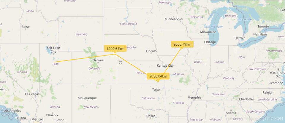
本文实例为大家分享了Openlayers实现距离面积测量的具体代码,供大家参考,具体内容如下
CSS
|
1
2
3
4
5
6
7
8
9
10
11
12
13
14
15
16
17
18
19
20
21
22
23
24
25
26
27
28
29
30
31
32
33
|
.ol-tooltip { position: relative; background: rgba(0, 0, 0, 0.5); border-radius: 4px; color: white; padding: 4px 8px; opacity: 0.7; white-space: nowrap; font-size: 12px; } .ol-tooltip-measure { opacity: 1; font-weight: bold; } .ol-tooltip-static { background-color: #ffcc33; color: black; border: 1px solid white; } .ol-tooltip-measure:before, .ol-tooltip-static:before { border-top: 6px solid rgba(0, 0, 0, 0.5); border-right: 6px solid transparent; border-left: 6px solid transparent; content: ""; position: absolute; bottom: -6px; margin-left: -7px; left: 50%; } .ol-tooltip-static:before { border-top-color: #ffcc33;} |
具体实现
|
1
2
3
4
5
6
7
8
9
10
11
12
13
14
15
16
17
18
19
20
21
22
23
24
25
26
27
28
29
30
31
32
33
34
35
36
37
38
39
40
41
42
43
44
45
46
47
48
49
50
51
52
53
54
55
56
57
58
59
60
61
62
63
64
65
66
67
68
69
70
71
72
73
74
75
76
77
78
79
80
81
82
83
84
85
86
87
88
89
90
91
92
93
94
95
96
97
98
99
100
101
102
103
104
105
106
107
108
109
110
111
112
113
114
115
116
117
118
119
120
121
122
123
124
125
126
127
128
129
130
131
132
133
134
135
136
137
138
139
140
141
142
143
144
145
146
147
148
149
150
151
152
153
154
155
156
157
158
159
160
161
162
163
164
165
166
167
168
169
170
171
172
173
174
175
176
177
178
179
180
181
182
183
184
185
186
187
188
189
190
191
192
193
194
195
196
197
198
199
200
|
let layer_1 =new ol.layer.Tile({ source: new ol.source.OSM() }); let source = new ol.source.Vector(); let vector = new ol.layer.Vector({ source: source, style: new ol.style.Style({ fill: new ol.style.Fill({ color: 'rgba(255, 255, 255, 0.2)' }), stroke: new ol.style.Stroke({ color: '#ffcc33', width: 2 }), image: new ol.style.Circle({ radius: 7, fill: new ol.style.Fill({ color: '#ffcc33' }) }) }) }); let map=new ol.Map({ layers: [ layer_1 ,vector ], view: new ol.View({ center: [-11000000, 4600000], zoom: 5, }), target: 'map' }); let count=0; let draw; let sketch=new ol.Feature(); let listener; let helpTooltipElement; let helpTooltip; let measureTooltipElement; let measureTooltip; let continuePolygonMsg="继续点击绘制多边形"; let continueLineMsg="继续点击绘制线"; createMeasureTooltip(); createHelpTooltip(); let pointerMoveHandler=function(evt){ if (evt.dragging) { return; } /** @type {string} */ let helpMsg = 'Click to start drawing'; if (sketch) { let geom = (sketch.getGeometry()); if (geom instanceof ol.geom.Polygon) { helpMsg = continuePolygonMsg; } else if (geom instanceof ol.geom.LineString) { helpMsg = continueLineMsg; } } helpTooltipElement.classList.remove('hidden'); }; map.on('pointermove', pointerMoveHandler); map.getViewport().addEventListener('mouseout', function() { }); let formatLength=function (line) { let length = ol.sphere.getLength(line); let output; if(length>100){ output=(Math.round(length/1000*100)/100)+''+'km' }else{ output=(Math.round(length*100)/100)+''+'m' } return output; }; let formatArea=function (polygon) { let area = ol.sphere.getArea(polygon); let output; if(area>10000){ output=(Math.round(area/1000000*100)/100)+''+'km<sup>2</sup>' }else{ output=(Math.round(area*100)/100)+''+'m<sup>2</sup>' } return output; }; function addInteraction(){ let type="Polygon"; draw=new ol.interaction.Draw({ source:source, type:type, style: new ol.style.Style({ fill: new ol.style.Fill({ color: 'rgba(255, 255, 255, 0.2)' }), stroke: new ol.style.Stroke({ color: 'rgba(0, 0, 0, 0.5)', lineDash: [10, 10], width: 2 }), image: new ol.style.Circle({ radius: 5, stroke: new ol.style.Stroke({ color: 'rgba(0, 0, 0, 0.7)' }), fill: new ol.style.Fill({ color: 'rgba(255, 255, 255, 0.2)' }) }) }), snapTolerance:50 }); map.addInteraction(draw); map.on('singleclick',function (evt) { measureTooltip.setPosition(evt.coordinate); if(count==0){ measureTooltipElement.innerHTML='起点' }else{ measureTooltipElement.className = 'ol-tooltip ol-tooltip-static'; measureTooltip.setOffset([0, -20]); // unset sketch sketch = null; // unset tooltip so that a new one can be created measureTooltipElement = null; createMeasureTooltip(); //map.removeInteraction(draw); } createMeasureTooltip(); //点击次数增加 count++; }); draw.on('drawstart',function (evt) { sketch=evt.feature; let tooltipCoord=evt.coordinate; listener=sketch.getGeometry().on('change',function (evt) { let geom=evt.target; let output; if(geom instanceof ol.geom.Polygon){ map.removeEventListener('singleclick'); output=formatArea(geom); tooltipCoord=geom.getInteriorPoint().getCoordinates(); }else if(geom instanceof ol.geom.LineString){ output=formatLength(geom); tooltipCoord=geom.getLastCoordinate(); } measureTooltipElement.innerHTML = output; measureTooltip.setPosition(tooltipCoord); }) }); draw.on('drawend', function() { measureTooltipElement.className = 'ol-tooltip ol-tooltip-static'; measureTooltip.setOffset([0, -7]); // unset sketch sketch = null; // unset tooltip so that a new one can be created measureTooltipElement = null; createMeasureTooltip(); map.removeInteraction('singleclick'); count=0; ol.Observable.unByKey(listener); }); } function createHelpTooltip() { if (helpTooltipElement) { helpTooltipElement.parentNode.removeChild(helpTooltipElement); } helpTooltipElement = document.createElement('div'); helpTooltipElement.className = 'ol-tooltip hidden'; helpTooltip = new ol.Overlay({ element: helpTooltipElement, offset: [15, 0], positioning: 'center-left' }); map.addOverlay(helpTooltip); } /** * Creates a new measure tooltip */ function createMeasureTooltip() { if (measureTooltipElement) { measureTooltipElement.parentNode.removeChild(measureTooltipElement); } measureTooltipElement = document.createElement('div'); measureTooltipElement.className = 'ol-tooltip ol-tooltip-measure'; measureTooltip = new ol.Overlay({ element: measureTooltipElement, offset: [-30, -30], positioning: 'center-center' }); map.addOverlay(measureTooltip); } /** * Let user change the geometry type. */ addInteraction(); |
参考官网教程
在线引用地址
|
1
2
|
<link rel="stylesheeth" ref="https://openlayers.org/en/v5.3.0/css/ol.css" type="text/css"><script src="https://openlayers.org/en/v5.3.0/build/ol.js"></script> |
多了一个singleclick来用于显示距离测量时每个线段节点到起点的距离
绘制类型我写死为Polygon了 注意自己修改一下

以上就是本文的全部内容,希望对大家的学习有所帮助,也希望大家多多支持服务器之家。
原文链接:https://blog.csdn.net/a1771744344/article/details/107310794


