本文实例为大家分享了Vue+penlayers实现多边形绘制展示代码,供大家参考,具体内容如下
|
1
2
3
4
5
6
7
8
9
10
11
12
13
14
15
16
17
18
19
20
21
22
23
24
25
26
27
28
29
30
31
32
33
34
35
36
37
38
39
40
41
42
43
44
45
46
47
48
49
50
51
52
53
54
55
56
57
58
59
60
61
62
63
64
65
66
67
68
69
70
71
72
73
74
75
76
77
78
79
80
81
82
83
84
85
86
87
88
89
90
91
92
93
94
95
96
97
98
99
100
101
102
103
104
105
106
107
108
109
110
111
112
113
114
115
116
117
118
119
120
121
122
123
124
125
126
127
128
129
130
131
132
133
134
135
136
137
138
139
140
141
142
143
144
145
146
147
148
149
150
151
152
153
154
155
156
157
158
159
160
161
162
163
164
165
166
167
168
169
170
171
172
173
174
175
|
<!-- * @Description: 绘制多边形 * @Author: Dragon * @Date: 2020-12-17 16:02:06 * @LastEditTime: 2020-12-18 17:20:33 * @LastEditors: Dragon--><template> <div> <div class="query-wrap"> <el-button type="primary" @click="drawStart('Polygon')"> {{ isDraw ? "绘制区域" : "重新绘制" }} </el-button> </div> <div id="map"></div> </div></template><script>import "ol/ol.css";import { Map, View } from "ol";import { Image as ImageLayer, Vector as VectorLayer } from "ol/layer";import { ImageStatic, Vector as VectorSource } from "ol/source";import { getCenter } from "ol/extent";import { Projection } from "ol/proj";import Draw from "ol/interaction/Draw";import { Style, Fill, Stroke } from "ol/style";import { GeoJSON } from "ol/format";import staticMap from "@/assets/map.png";export default { data() { return { map: null, // 地图 imgx: 0, // 当前地图宽 imgy: 0, // 当前地图高 isDraw: true, // 是否绘制 draw: null, source: null, vector: null, styles: [ new Style({ stroke: new Stroke({ color: "rgba(255,0,0,0.6)", width: 2, }), fill: new Fill({ color: "rgba(255,0,0,0.3)", }), }), ], geojsonObject: { 'type': 'FeatureCollection', 'features': [ { 'type': 'Feature', 'geometry': { 'type': 'Polygon', 'coordinates': [ [ [97.16862961519749, 322.26517247174047], [117.3211820327625, 481.9353954724479], [1.056456546810466, 489.6863771715114], [13.458027265312012, 320.71497613192776], [97.16862961519749, 322.26517247174047] ] ], }, }, ], }, }; }, methods: { // 初始化地图 initMap() { let extent = [0, 0, this.imgx, this.imgy]; let projection = new Projection({ code: "xkcd-image", units: "pixels", extent: extent, }); let $this = this; this.map = new Map({ target: "map", layers: [ new ImageLayer({ // 展示地图层 source: new ImageStatic({ url: staticMap, projection: projection, imageExtent: extent, }), }), new VectorLayer({ source: new VectorSource({ features: new GeoJSON().readFeatures($this.geojsonObject), }), style: $this.styles, }), ], view: new View({ projection: projection, center: getCenter(extent), zoom: 2, maxZoom: 18, }), }); this.source = new VectorSource({ wrapX: false }) this.vector = new VectorLayer({ source: this.source, style: this.styles }) this.map.addLayer(this.vector) }, // 开始绘制多边形 drawStart(type) { let that = this; if(this.isDraw) { this.isDraw = false this.draw = new Draw({ source: this.source, type: type, }); this.map.addInteraction(this.draw); this.draw.on("drawend", function (evt) { that.drawingEnd(evt); }); } else { this.source.clear() this.map.removeInteraction(this.draw); this.isDraw = true } }, // 构建多边形结束 drawingEnd(evt) { let that = this const geo = evt.feature.getGeometry(); const t = geo.getType(); if (t === "Polygon") { // 获取坐标点 const points = geo.getCoordinates(); console.warn(points, "绘制结束,点坐标") this.map.removeInteraction(this.draw); // 移除绘制 } }, }, mounted() { let that = this; let img = new Image(); setTimeout(function() { img.src = staticMap; img.onload = function (res) { that.imgx = res.target.width; that.imgy = res.target.height; that.initMap(); }; }, 500) },};</script><style>#map { width: 100%; height: calc(100vh - 50px);}</style> |
效果图:
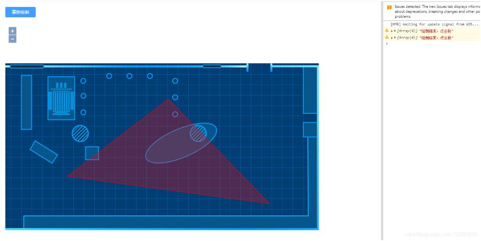
以上就是本文的全部内容,希望对大家的学习有所帮助,也希望大家多多支持服务器之家。
原文链接:https://blog.csdn.net/LONG_Yi_1994/article/details/107058286

